
Best in Travel
The 30 best countries, cities and regions to visit in 2025

See where a Lonely Planet Membership takes you
Plan your trip with Elsewhere, by Lonely Planet
Book with our partner, GetYourGuide

Subscribe to our weekly newsletters to get the latest travel news, expert advice, and insider recommendations
Articles by interest

Every month, we release new books into the wild

Explore the world with our detailed, insightful guidebooks

Stay ahead of the curve with our guidebooks

Uncover exciting new ways to explore iconic destinations

Download instantly and read any time
Apr 16, 2025 • 11 min read
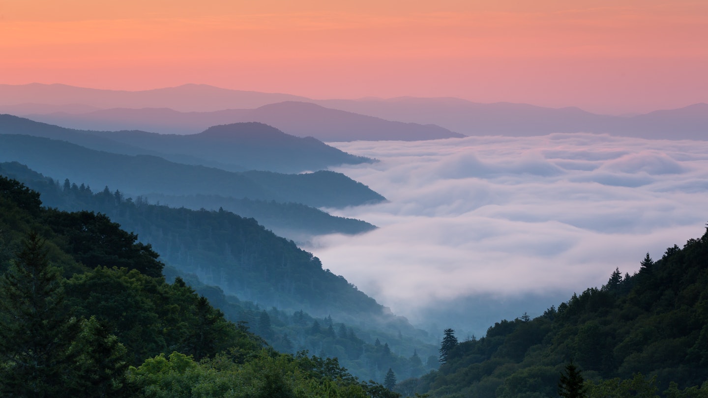
Sunrise in Great Smoky Mountains National Park. Keneva Photography/Shutterstock
You can observe the beauty of the Great Smokies from your car, but the exhilarating, crash-bang, breathe-it-in wonder of the place can’t be fully appreciated until you leave your vehicle. Hold tight as you bounce over Nantahala rapids. Nod to foraging black bears as you bicycle Cades Cove. And press your nose against windows in downtown Gatlinburg, Tennessee, where ogling short stacks is the best way to choose the right pancake place.
Explore Great Smoky Mountains National Park and the surrounding region with this road trip itinerary from the North Carolina side of the Smokies to Tennessee. Here’s what to do at each stop and how to get to the next one. (Due to National Park Service staffing cuts this year, travelers can expect longer wait times, fewer services and the potential closures of certain areas. Stay prepared with this guide.)
Duration: 4-5 days
Distance: 160 miles (257km)
Best time to go: April to June for waterfalls, and September and October for colorful leaves.

Splash, bang, wheeeeee…there’s no easing into this trip, which starts in the mountain-fed rivers and rugged valleys of western North Carolina, a region famed for its fantastic kayaking and white-water rafting. The launches trips on the class II and class III rapids of the Nantahala River from its sprawling outpost near Bryson City. Ride a group raft or a two-person ducky through the wide, brown river gorge. The company also offers white-water trips on six other Appalachian rivers.
At the Adventure Center, sign up to zipline or climb an alpine tower. Also on site are an outdoor store, a year-round restaurant, and lodging that includes campsites, cabins, a hostel and a motel. The Appalachian Trail crosses the property, and the Great Smoky Mountains Railroad stops here.
The drive: Follow US 19 north for about 12.5 miles on a twisty, wooded path that winds past rafting companies and oh-so-many signs for boiled peanuts. Take exit 67 into downtown Bryson City.
This friendly mountain town is a great base camp for exploring the North Carolina side of the Smokies. The marquee attraction is the historic , which departs from downtown and plows through the Nantahala Gorge and across the Fontana Trestle. The former Murphy Branch Line, built in the late 1800s, brought unheard-of luxuries such as books, factory-spun cloth and oil lamps. Themed trips on the red-and-yellow trains include a Great Pumpkin–themed trip in the fall and the Christmastime Polar Express, which stops at the North Pole to pick up Santa.
The drive: Continue 11 miles north on US 19.
The Cherokee people have lived in this area since the last ice age, though many died on the Trail of Tears. The descendants of those who escaped or returned are known as the Eastern Band of the Cherokee. Make time for the . The earth-colored halls trace the history of the tribe, with artifacts such as pots, deerskins, woven skirts and an animated exhibit on Cherokee lore. The tribe’s modern story is particularly compelling, with a detailed look at the tragedy and injustice of the Trail of Tears. This mass expulsion occurred in the 1830s, when President Andrew Jackson ordered more than 16,000 Native Americans removed from their southeastern homelands and resettled in what’s now Oklahoma. The museum also spotlights a fascinating moment in Colonial-era history: the 1760s journey of three Cherokee to England, where they met with George III.
The drive: Drive 3 miles north on US 441, passing the Blue Ridge Parkway.

If they’re offering samples of regional preserves at the , say yes. But pull out your money, too, because you’ll want to buy a jar to take home. You’ll also find interactive exhibits about the park’s history and ecosystems here. Helpful guides about specific attractions are also available. For this trip, the Day Hikes pamphlet and the guides to Cades Cove and the Roaring Fork Motor Nature Trail are helpful supplements. Behind the visitor center, the pet-friendly Oconaluftee River Trail follows the river for 1.5 miles to the boundary of the Cherokee reservation. Pick up a free backcountry camping permit if you plan to go off-trail. The adjacent Mountain Farm Museum is a 19th-century farmstead assembled from buildings from various locations around the park. The worn, wooden structures – including a barn, a blacksmith shop and a smokehouse – give a glimpse of the hardscrabble existence of Appalachian settlers.
The drive: Drive half a mile north on US 441. The parking lot is on the left.
Interested in old buildings and 1800s commerce? Then take the short walk to Mingus Mill. This 1886 gristmill was the largest in the Smokies. If the miller is there, he can explain how the mill grinds corn into cornmeal. Outside, the 200-ft-long wooden millrace directs water to the building. There’s no waterwheel here because the mill used a cast-iron turbine.
The drive: Return to US 441 and turn left, continuing toward Gatlinburg. Turn left onto Clingmans Dome Rd and drive for 7 miles.
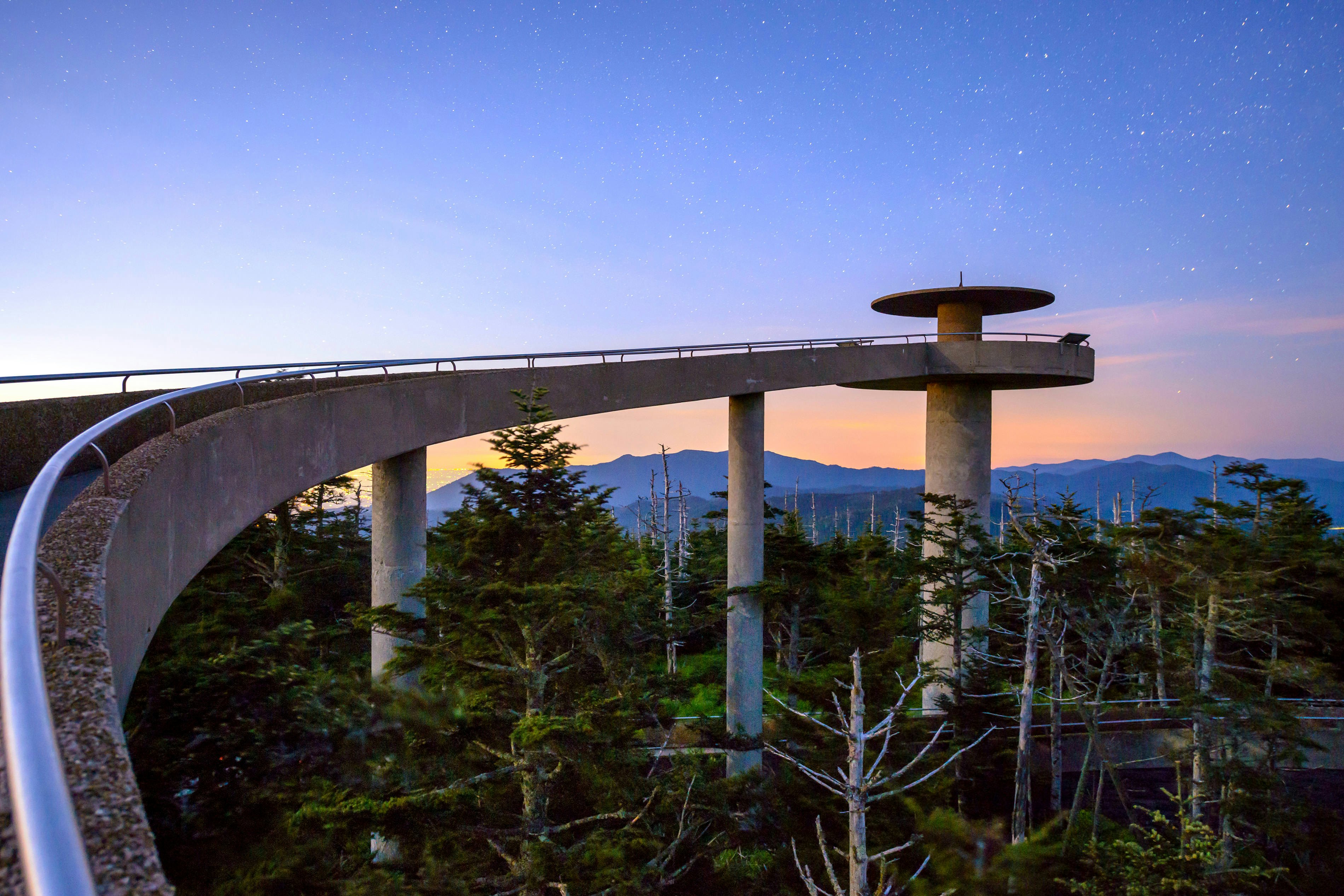
At 6643ft, Clingmans Dome is the third-highest mountain east of the Mississippi. You can drive almost all the way to the top, but the final climb to the summit’s Jetsons-like observation tower requires a half-mile walk on a paved trail. It’s a very steep ascent, but there are resting spots along the way. The trail crosses the 2174-mile Appalachian Trail, which reaches its highest point on the Dome. From the tower, on a clear day, enjoy a 360-degree view that takes in five states. Spruce- and pine-covered mountaintops sprawl for miles. The visitor station beside the parking lot has a bookstore and shop. The weather here is cooler than at lower elevations, and rain can arrive quickly, so consider wearing layers and bringing a rain poncho.
The drive: Follow Clingmans Dome Rd back to US 441. Cross US 441 and pull into the overlook parking area.
There’s a lot going on at the intersection of US 441 and Clingmans Dome Rd. Here, the Rockefeller Monument pays tribute to a $5 million donation from the Rockefeller Foundation that helped to complete land purchases needed to create the park. President Franklin D Roosevelt formally dedicated Great Smoky Mountains National Park in this spot in 1940. The overlook sits at the border of North Carolina and Tennessee, within the 5046ft Newfound Gap. Enjoy expansive mountain views from the parking area or hop on the Appalachian Trail for a stroll.
The drive: From here, follow US 441 north into Tennessee for about 5 miles to the parking lot.

Climbing 6593ft Mt LeConte is probably the park’s most popular challenge and is sure to give you serious hamstring burn. The Alum Cave Trail, one of five routes to the peak, starts from the Alum Cave parking area on the main road. Follow a creek, pass under a stone arch and wind your way steadily upward past thickets of rhododendron, myrtle and mountain laurel. It’s a 5.5-mile hike to LeConte Lodge, where you can join the Rainbow Falls Trail to the summit.
The drive: Continue on Newfound Gap Rd. Turn left into the parking lot at Little River Rd.
At the junction of Little River and Newfound Gap Rds is , the park’s headquarters and its main Tennessee entrance. Step inside for exhibits about plant and animal life (there’s a stuffed wild boar only a mama boar could love) and a bookstore. Several ranger-led talks and tours meet at Sugarlands.
The drive: Turn onto Little River Rd for a gorgeous 25-mile drive beside lively flowing waterways. The road passes Elkmont Campground and then becomes Laurel Creek Rd. Watch for cars stopping suddenly as drivers pull over to look at wildlife.
This secluded valley contains the remnants of a 19th-century settlement. It’s accessed by an 11-mile, one-way loop road that has numerous pull-offs. From there, you can poke around old churches and farmhouses or hike trails through postcard-perfect meadows filled with deer, wild turkeys and the occasional bear. For good wildlife viewing, come in the late afternoon, when the animals romp with abandon. The narrow loop road has a speed limit of 10mph and can get crowded (and maddeningly slow) in high season.
For a more tranquil experience, ride your bike, or walk on a Wednesday – cars are banned on that day of the week from early May through late September. Rent a bike at the Cades Cove Campground Store. Also recommended is the 5-mile round-trip hike to Abrams Falls. Trailhead parking is just beyond the Elijah Oliver Place, an old homestead. Stop by the Cades Cove Visitor Center for ranger talks.
The drive: Return to Sugarlands Visitor Center, then turn left onto US 441, which is called Parkway between Gatlinburg and Sevierville. Drive 2 miles to Gatlinburg.

Driving out of the park on the Tennessee side is disconcerting. You pop out of the tranquil green tunnel of trees into a blinking, shrieking welter of cars, motels, pancake houses, moonshine distilleries and Ripley’s Believe It or Not museums. Welcome to Gatlinburg. It’s Heidi meets hillbilly in this vaguely Bavarian-themed tourist wonderland, catering to Smokies visitors since the 1930s. Most of the tourist attractions are within the compact, hilly little downtown. The Gatlinburg Sky Lift, a repurposed ski-resort chairlift, whisks you high over the Smokies. An observation deck and a 680-ft-long suspension bridge, the longest in North America, opened at the top of the lift in spring 2019.
The drive: From Parkway in downtown Gatlinburg, turn right onto Historic Nature Trail/Airport Rd at the Gatlinburg Convention Center. Follow it into the national park, continuing to the marked entrance for the one-way Roaring Fork Motor Nature Trail.
Built on the foundations of a 150-year-old wagon road, the 6-mile loop twists through strikingly lush forest. Sights include burbling cascades, abundant hardwoods, mossy boulders and old cabins once inhabited by farming families. The isolated community of Roaring Fork was settled in the mid-1800s, along a powerful mountain stream. The families that lived here were forced to move when the park was established about 100 years later.
For a waterfall hike, try the 2.6-mile round-trip walk to Grotto Falls from the Trillium Gap Trailhead. Further down the road, check out the tiny Ephraim Bales cabin, once home to 11 people, believe it or not. The Roaring Fork Auto Tour Guide, for sale for $1 in the Oconaluftee and Sugarlands visitor centers, provides details about plant life and buildings along the drive. No buses, trailers or RVs are permitted on the motor road.
The drive: At the end of Roaring Fork Rd, turn left onto E Pkwy. Less than 1 mile ahead, turn right at US 321 S/US 441. Drive 7 miles to Pigeon Forge.
The town of Pigeon Forge is an ode to that big-haired angel of East Tennessee: Dolly Parton – who’s known to be a pretty cool lady. Born in a one-room shack in the nearby hamlet of Locust Ridge, Parton started performing on Knoxville radio at age 11 and moved to Nashville at 18 with all her worldly belongings in a cardboard suitcase. She’s made millions singing about her Smoky Mountains roots and continues to be a huge presence in her hometown, donating money to local causes. The town's main drag, Parkway, is lined with wacky museums and over-the-top dinner shows.
The drive: From Patriot Park, turn right onto Old Mill Ave and follow it to Teaster Lane. Turn right onto Teaster Lane, then turn left at the light onto Veterans Blvd. Follow signs to Dollywood, about 2 miles away. You can also catch the Fun Time Trolley ($2.50 one way) to Dollywood from Patriot Park, where there’s free parking.

Dolly Parton’s theme park is a love letter to mountain culture. Families pour in to ride the country-themed thrill rides and see demonstrations of traditional Appalachian crafts. The roller coasters are nationally acclaimed. You can also tour the bald-eagle sanctuary or visit the Dolly Parton Experience life-story museum. The 6-acre Wildwood Grove section of the park is geared to younger kids. The adjacent Dollywood’s Splash Country takes the amusement park’s themes and adds water.
The drive: Return to Parkway and follow it north 4.5 miles into downtown Sevierville. Turn left onto Bruce St and drive one block to Court Ave.
On the front lawn of the downtown courthouse, you might see a few happy folks getting their pictures taken in front of the statue of a young Dolly Parton. Wearing a ponytail, her guitar held loose, it captures something kind of nice. You know where she’s from, where her music’s going to take her, and how it all ties into this tough but beautiful mountain country.
This article was adapted from Lonely Planet's .